Gullies supply most sediment to major East Coast river systems
Mike Marden, New Zealand Tree Grower August 2009.
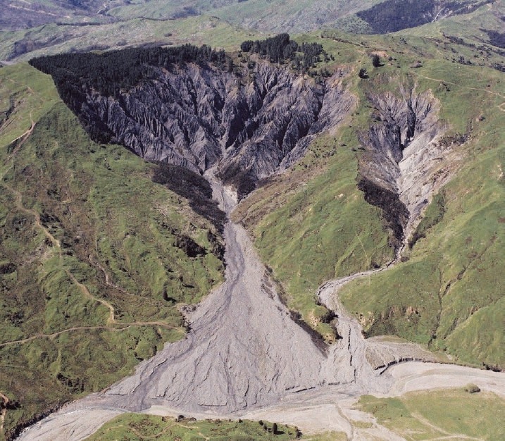
It has long been suspected that gullies have been, and continue to be, the major source of sediment in each of the three major East Coast river systems − Waipaoa, Waiapu and Uawa. However, until recently the number, location and size of gullies within these catchments have not been known, and therefore their contribution to the sediment load of these respective rivers has been largely speculative.
With the recent completion of gully mapping, in conjunction with gully degradation models, it is now possible to calculate how much sediment is generated by each gully. It is also possible to calculate how much is from gullies in different geological terrains and how much came from gullies associated with different land uses. In addition, the proportion of gully-derived sediment that leaves these catchments as suspended sediment can now be calculated.
Gully distribution
Using aerial photographic coverage of the whole East Coast region, a comparison was made between the distribution of gullies present in the late 1950s, before the beginning of reforestation for erosion control, with that at 1997.The analyses showed that the average size of gullies in the 1950s was less than one hectare. Of those that were treated, largely by reforestation, the majority had since stabilised resulting in a 31 per cent decrease in composite gully area.
In contrast, about 30 per cent of gullies present in the 1950s were not treated during this 40 year period. As a consequence they individually expanded in size and their composite gully area increased by 38 per cent. In addition, during this period more than 1000 new gullies were created. These were largely as a result of major storms such as cyclone Bola in 1988 which caused a 21 per cent increase in gully area.

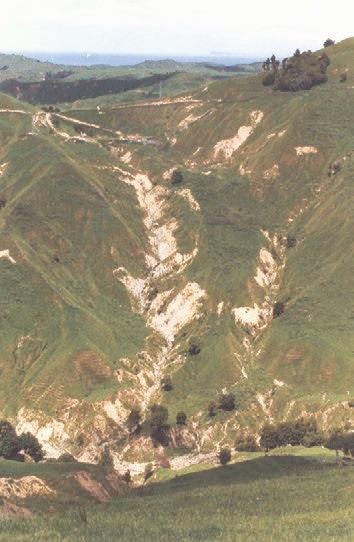
The highest proportion of this increase in composite gully area occurred on farmland. It happens because landowners are not targeting gullies for protection planting sufficiently early, if at all. This increase highlights the vulnerability of steep, gully-prone hill country to the new gullies. This is especially important in areas not previously identified and subsequently planted as a means of future-proofing them against the effect of major storms in the future. Overall, the result has been approximately a 27 per cent increase in composite gully area across the region since the late 1950s at a rate of about 112 hectares a year.
How many untreated gullies are there?
From aerial photography flown in 1997 more than 2,000 actively eroding gullies have been mapped. Excluding those gullies within existing areas of reverting scrub and exotic and indigenous forest, around 1,300 more gullies require treatment.
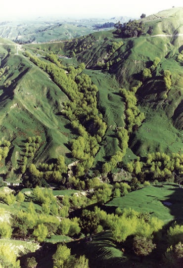
It is estimated that since 1997 about 500 of these gullies have subsequently been reforested or allowed to revert to indigenous scrub using financial help from the East Coast Forestry Project. An unknown number have also been planted in poplar poles. As a result bout 800 gullies located in areas of pastoral hill country still require protection planting.
Where these gullies are
Of the gullies currently considered to be active, about 80 per cent are found within the Waipaoa,Waiapu and Uawa catchments, with around half of these within the Waiapu catchment. Across the two broad geological terrains that exist in this region, 62 per cent of currently active gullies occur in areas of Tertiary terrain with the remainder located in areas of Cretaceous terrain.
This is a reversal of the situation found in the early 1960s. At that time there were a considerably greater number of gullies located within the more gully-prone Cretaceous land. However, beginning in the 1960s, areas of Cretaceous terrain were targeted for reforestation and many gullies once present have since stabilised. In contrast, over the same time period, considerably fewer gullies within areas of Tertiary terrain were targeted for treatment. Most of the new gullies initiated during cyclone Bola occurred in these areas.
The largest proportion of currently active gullies are found in areas of pastoral hill country, 18 per cent in exotic forest, 16 per cent in areas of reverting shrubland and three per cent in areas of remaining indigenous forest. The majority of gullies found in areas of reverting shrubland and indigenous forest occur in Waiapu catchment.
The net area affected by gully erosion in this region, including areas that have subsequently been treated, is a staggering 10,000 hectares. That is, within a 40-year period, 10,000 hectares of formerly productive pastoral land has degraded to the point where it has had to be retired from farming and protected from further deterioration by converting it back to a forest.
How much sediment do gullies produce?
Calculations of sediment produced by gullies within each of the three largest East Coast river systems over a 40-year period show that gullies within Waiapu catchment produced sediment at a rate of 17 million tonnes a year. The Waipaoa gullies produced 6.4 million tonnes a year while those in the Uawa catchment produced 2.7 million tonnes a year.
All this sediment was produced from gullies that occupy under 2.5 per cent of hill country areas in these river systems. So although gullies occupy just a small proportion of a catchment area they are capable of producing an enormous amount of sediment each and every year. It is this sediment that clogs the East Coast river systems and causes untold damage to bridges, roads and other forms of infrastructure.
Annual suspended sediment in rivers
The annual suspended sediment yield is the amount of material that exits each catchment annually as suspended sediment and ultimately ends up deposited in the ocean. For the Waiapu river it is 35 million tonnes a year, for the Waipaoa 15 million tonnes a year and for the Uawa 5 million tonnes a year. These are some of the highest recorded annual suspended sediment yields recorded for river systems of this size from anywhere in the world.
Each year in Waiapu catchment, gullies alone produce 17 million tonnes a year of sediment, equivalent to just under half the average annual suspended sediment yield of this river. Similarly gullies in the Waipaoa catchment produce 6.4 million tonnes a year equivalent to 43 per cent of this river’s average annual suspended sediment yield
Gullies in Uawa catchment produce 2.7 million tonnes a year equivalent to 54 per cent of its average annual suspended sediment yield. The conclusion is that gully erosion has been and remains the most significant sediment-producing process in these river systems. Until stabilised, gullies will continue to contribute the largest proportion of the respective river’s average annual suspended sediment yield.
Can gullies be successfully treated?
The choice of treatment option must be realistic. Many small gullies of less than a hectare in size can be treated with poplar poles. For the larger and generally more active gullies reforestation or natural reversion to native forest will provide the most effective long-term solution. Re-forestation has been the most successful mechanism employed to stabilise actively eroding gullies and is equally effective in reducing sediment production from them.


Its influence has been greatest in areas of Cretaceous terrain forested in stages since the 1960s and where plantings involved substantial areas of gully-prone land within the headwaters of these drainage basins. Replanting gullies has proved to be most successful for gullies of up to 15 hectares in size at the time of planting. To be effective, reforestation and reversion to native forest need sufficient numbers of trees to provide canopy closure. The closer the trees are planted, the sooner canopy closure will occur and the greater the chance that treatment will be successful. Research has shown that for reforested gullies approximately a hectare and less in size, 90 per cent were successfully stabilised within 20 years of being planted, and all within 30 years. In contrast, for five hectare gullies 60 per cent of those planted for 20 years and 90 per cent of those planted for 30 years were successfully stabilised.
For gullies larger than 10 hectares, only around 30 per cent of them will successfully stabilise within 20 years of planting and between 50 per cent and 70 per cent after 30 years. None of the gullies larger than 20 hectares in size had been successfully stabilised within 30 years of planting. Although most had reduced in size only a few had reduced by as much as half their original size. The key point is that the larger the gully the longer it will take to achieve effective stabilisation and to reduce the rate of sediment production from it. Gullies must be treated early.
Prioritising of gully replanting
Of the three major East Coast river systems, the greatest potential for achieving a significant reduction in sediment production and yield at the catchment scale is in the Waiapu catchment. This would require a more targeted approach than has been achieved in the past and would only involve a relatively small proportion of the total catchment area − the gullies themselves and their contributing watersheds.
Reforestation is the most practical and effective means of controlling gully erosion, and for all but the largest gullies it is achievable within one forest rotation of around 30 years. To achieve effective control of these gullies, particularly of the medium to large ones, the area to be treated would probably need the inclusion of adjacent areas of associated mass movement. This would incorporate part or the entire watershed surrounding each gully. There will be exceptions to this general rule. Many site factors need to be taken into account before deciding on a management boundary that does not compromise the effectiveness of the proposed treatment.
Reducing sediment
To reduce the supply of gully-derived sediment significantly will need a genuine attempt to treat a substantial number of the currently active gullies within a short period of time. Even then it will take several decades before the beneficial influences of gully stabilisation will result in a decline in sediment production.
In particular, the sediment yield for Waiapu River will remain at current levels until sediment already stored in its heavily aggraded riverbed has been excavated. Until this process is underway it will not be possible, in the short term, to achieve other potential environmental benefits. These will be improved water clarity and quality, a reduction in channel aggradation, flood risk, or cost savings associated with bridge replacement and repairs to flood-damaged roads.
The gully erosion problem in the Waiapu catchment, and elsewhere in this region, is not insurmountable but research to date shows that gully erosion has not been kept in check. The way forward is to acknowledge that gully erosion is a major problem in parts of this catchment and unless existing gullies are treated the problem will worsen. In addition, given the climate scenarios predicted for this region, it is likely that unless the gully erosion problem is dealt with, it will become a major obstacle for land use sustainability in Waiapu catchment. This could affect the economic viability of the region as a whole.
It is clear that a concerted effort is required to increase the momentum for managing gully erosion. All concerned, including landowners, Gisborne District Council and MAF must work together for the benefit of the region and its rate – payers.
Attractive funding levels are available through the East Coast Forestry Project specifically to target gully erosion. Together with other funding mechanisms it would be possible to achieve significant reductions in the sediment from gullies. To capitalise on funding available action is needed now so that the task of treating all existing gullies could be completed before this fund is terminated in 2020.
Mike Marden, Landcare Research, Gisborne.
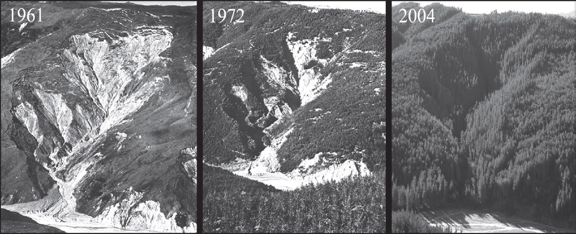
A gully in Te Weraroa stream, Mangatu Forest
Pinus nigra was planted in 1962 on the lesser-eroded surrounds of this gully. Then in 1966 radiata pine was planted on the steeper and more severely eroding slopes immediately flanking the gully and within the gully itself. By 1972 the effectiveness of the plantings in stabilising the gully was apparent.
Planting within the gullies in 1974 with radiata pine was undertaken on the remainder of bare slopes and the fan. Before planting, this gully was 7.6 hectares in size and by 1988 reforestation had reduced the area of active erosion to 0.8 hectares.
The latest photograph shows that in spite of a cyclone Bola in 1988 this, and similarly reforested gullies of this size have remained stable. The elevation difference between stream level and the ridge at the head of this gully is 280 metres.


 Farm Forestry New Zealand